


Building your world: coasts
- Aug 17, 2017
- 14 min read
Topic of today: coasts!
Location: where land meets the sea.
Description: from cliff coasts to sandy shores. Sometimes featuring hot surfer dudes.
Coasts cover a small part of the world's surface, but they are the best. And I'm totally not biased because I'm a coastal researcher; Wikipedia told me that, according to the UN atlas, 44% of people live within 150 kilometres of the sea (150 km counts as coast, apparently. There seem to be some hiccups with the exact definition). The coastal zone is where land and sea meet, a highly dynamic place where waves and tide carve the land. 'Dynamic' truly is the keyword here; coasts change constantly.


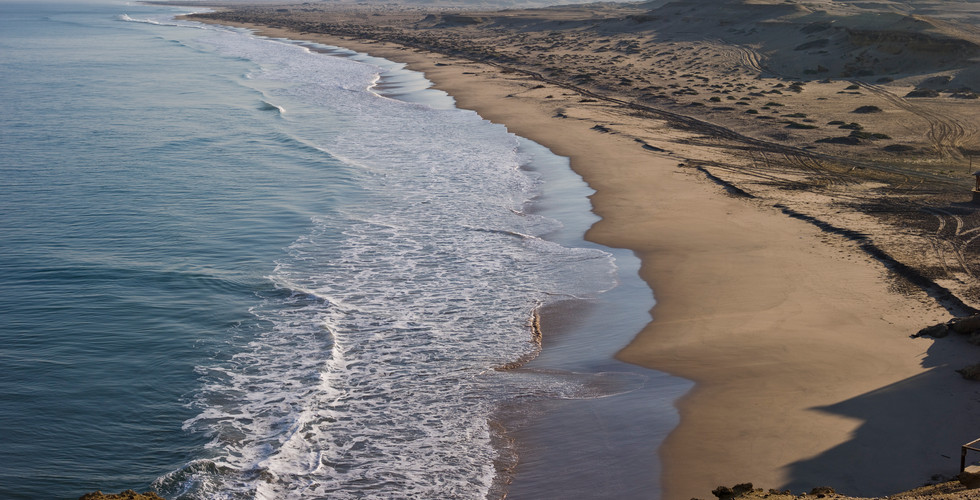
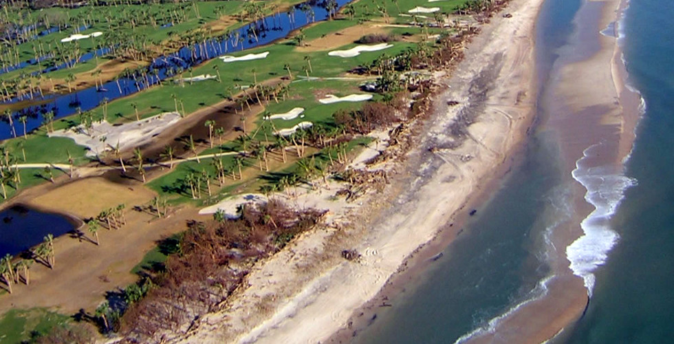
What a nice, broad beach! Oh wait...
Egmond aan Zee, the Netherlands. You are looking at a part of my research' dataset.
I have to start with a little disclaimer: this topic is huge. I had to ignore quite a bit to keep this post concise. I will not mention river deltas, for example, but don't worry, they will have their own post one day. Just keep in mind that a coast is not a closed feature; it interacts with other things. Hmm, that applies to many things that shape our Earth, to be honest.
Sediment balance
Coasts are shaped by many things: waves, tides, wind, humans (!)... I can't go through all of them in detail, unfortunately, but it boils down to this: the wind creates waves and currents. When waves approach the coast, they will 'feel' the bottom at some point, which will cause them to break. Furthermore, when they feel the bottom, they will also stir sediment. This all leads to a very complex sediment transport system which can either lead to sediment getting transported to the coast or further away from it. I know, that doesn't sound like much of an answer, but it gives us coastal scientists something to study. To make matters even more complex, things like storms will affect the waves and water level. Tides will alter the latter as well, and will therefore influence which part of the beach gets affected by waves. And we are not done yet, because the sediment that makes it to the beach gets transported further inland by the wind.
Let's get back to sediments in the water, because that's what this is all about. Erosion and sedimentation determine what will happen to a coast. It is a system of fluxes; if the amount of sediment entering the coastal zone surpasses the amount that leaves, you get deposition and vice versa.
Erosion comes from waves stirring sediment, but also salt and water weathering rock. Erosion thrives under high-energy conditions, meaning the waves are high, which is what happens when a strong wind blows across a stretch of water (a.k.a. fetch) for a long time - in other words, stormy conditions. A high water table helps the waves get further inland to erode coastal dunes or cliffs, which is why high tides and storms are a deadly combination. I hope you don't mind if I save storms and tide for a different post; if you look at this one, you can see it's long enough already.
Sedimentation also comes from waves, but here, waves and currents loose their strength and therefore their sediment carrying capability. This sediment can come from deeper parts of the sea, rivers, or, ironically, an eroding coast not that far away. Sedimentation happens during calm weather, and is a much slower process than erosion. A sandy coast that suffered from a storm event that lasted only a few days needs months to recover and grow.
Coastal evolution
The play between erosion and sedimentation determines what will happen to a coast. More sedimentation = growth, more erosion = decline. Sounds easy, right? However, there are plenty of things you need to keep in mind here. For example, sea level rise does not automatically mean a retreating coast; if sediment supply can keep up with the rising sea level, your coast will stay where it is or even grow (for those who now think this will solve our current sea level problem: sorry, our world is drowning).
Coasts have a tendency to be straight - or better, they want to be (there might be some small-scale features, but I'm ignoring those for the moment). Why? Because every bit of land that sticks out will 'attract' waves and therefore erosive energy. Waves in deeper water move faster than waves in shallow water. Now, if you have a coast with a piece of headland sticking out, the water around it will be shallower. The part of the wave closest to the headland will slow down earlier than the rest of the wave, which causes the wave to turn towards the headland, which is known as wave refraction. Imagine a car axle with its left wheel rotating faster than the right one; the axle will turn to the right, to its slower wheel. Waves do the same, which makes their energy focus on one point. More energy = stronger erosion. The opposite happens as well; if waves enter a bay, their energy spreads out over a large area, making the waves weaker. These are areas of sedimentation. I can see you thinking: 'why are there headlands and bays in the first place then?'. Well, that has to do with the pre-existing geology, which brings us to our next topic:
Rocky, sandy, muddy (and icy?)
These are the materials coasts can be made of. Hard rock will not give in to the water's erosive powers easily, no matter how energetic the waves are. Softer sediments will erode much easier. If you have a coastline with mixed bedrock, it will affect the looks of your coast. At discordant coastlines, the rock layers lie perpendicular to the coast. On concordant coastlines, these layers run parallel.
Not all shores are made of solid rock; they can be covered with boulders, pebbles, gravel, sand, or mud - sometimes a combination of these. Remember, the bigger and heavier the particle is, the harder it is to move, but also the easier it will settle. You need large waves to get a boulder moving, but only little ones to move mud. That said, mud will only settle during very calm conditions.
Rocky coastlines have little sediment input. Sandy coasts, on the other hand, have a sandy source whose sediments get distributed by waves. You can think of rivers as a source, but the sand can also be already there, being deposited in older eras. Muddy coastlines need calm conditions, so they have almost no waves. Their sediments can be deposited by the tide or rivers, and can often be found in sheltered bays or river mouths.
Ice is quite special; thick ice sheets may act like rocky cliffs, except that it floats. Freezing and thawing cycles can weaken rock, while meltwater runoff washes away sediments. I think I'm going a bit off topic with this, but feel free to ask about arctic phenomena if you have questions.


Flora and fauna
The sea is filled with life, and the coastal zone is a popular place to be. Flora and fauna affect the look of a coast as well. Please keep in mind that ecology is not my field of expertise, so I will be brief. I guess it's obvious that certain species only thrive under certain temperatures. For example; muddy coasts in temperate climates will have mudflats with algae and muscles growing on them, but in tropical regions, these muddy coasts will turn into mangroves. Same goes for coral reefs; certain types of coral needs specific conditions to live, but once you have it, it will alter a coast strongly. Roots of plants keep soil together, making a coast more resistant to erosion. On the other hand, roots can also creep into cracks in rock and widen them, stimulating erosion. Really, this topic doesn't seem to have an end...
Quite an infodump, don't you think? So we covered how coasts works and what they are made of, but you can sort coasts according to their looks as well. There are two types, but I added a third because I think it deserves to be mentioned too.
1. Cliff coasts
Cliff coasts are always erosive, but how quickly they retreat depends on the rock type and wave characteristics (a.k.a. wave climate). There are so called dead and active cliff coasts; dead ones only erode during very high waves and water levels, while active cliffs erode constantly. Most famous cliff coasts are made of hard rock, but they can occur in softer sediment too, though those will suffer from collapse quickly. Cliff coasts have little to no sediment input.
Features:
Headlands and bays - headlands are land that sticks out into sea, while bays do the opposite. How, where and if a coast develops headlands and bays depend on its geology; soft rock erodes quicker, creating bays, while hard rock is more resistant.
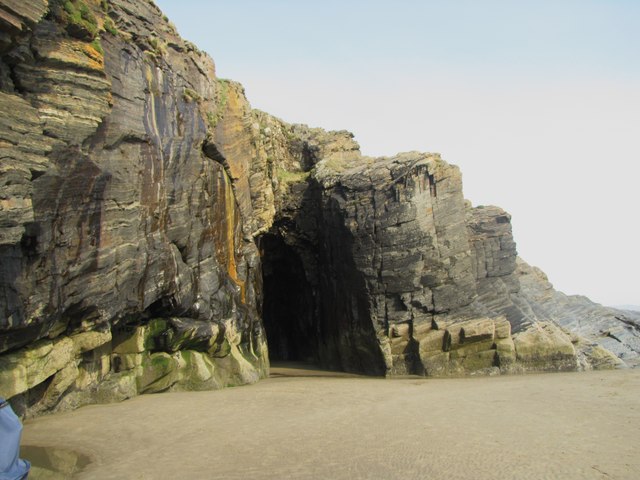
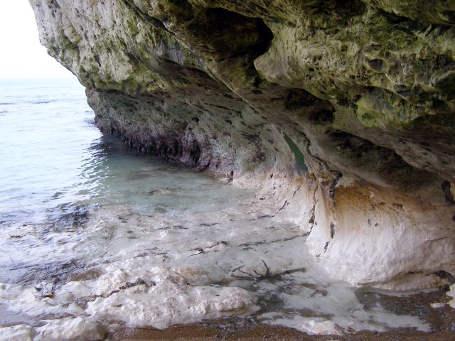
Wave-cut notch - Waves can only reach the lower part of a cliff, creating an overhanging rock. The rock above can fall down when the undercutting becomes too severe, or the undercutting can develop into a cave.
Shore platform - the flat beach in front of a cliff, where collapsed material ends up on.
Caves - a.k.a. littoral caves. Caves do not exist forever; one day, they will collapse. The size of a cave depends on the strength of the rock: the stronger, the bigger. Magmatic rock types therefore produce the biggest sea caves.
Blowholes - when a cave has a vertical shaft that leads to the surface, a wave can blow through it, resulting in a spray of water that looks like a geyser (though lasts a lot shorter). These vertical shafts aren't created by waves though; they are already existing crevices in the bedrock.
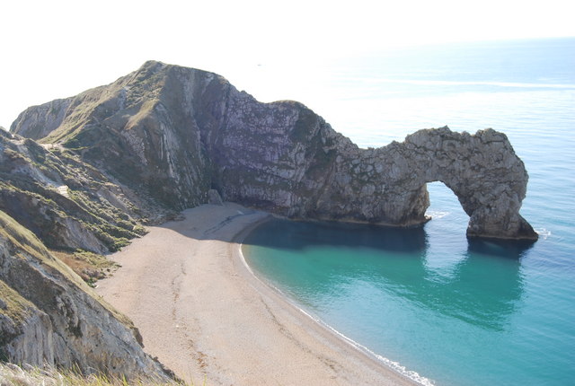
Arches - Similar to caves, but with an exit nearby. Arches often form from headlands that have become so narrow the sea undercuts it.
Stacks - Arches collapse. This is the pillar that remains. Headlands can also immediately erode to stacks if they cannot form an arch first.
Coves - a sheltered bay. Imagine a coast made of different types of rock running parallel to the coastline. The hardest rock can be found at the sea, weaker rocks (or sediment) can be found inland. The sea has a hard time eroding that hard rock, but when it breaks through, it will erode the weaker stuff more easily. This creates small, sheltered bays.
Erosional features - rocky coasts are cut back constantly, and the scars of waves scraping pebbles across its cliffs (a.k.a. abrasion), weathering due to (bio)chemicals, and rock falls are visible everywhere.


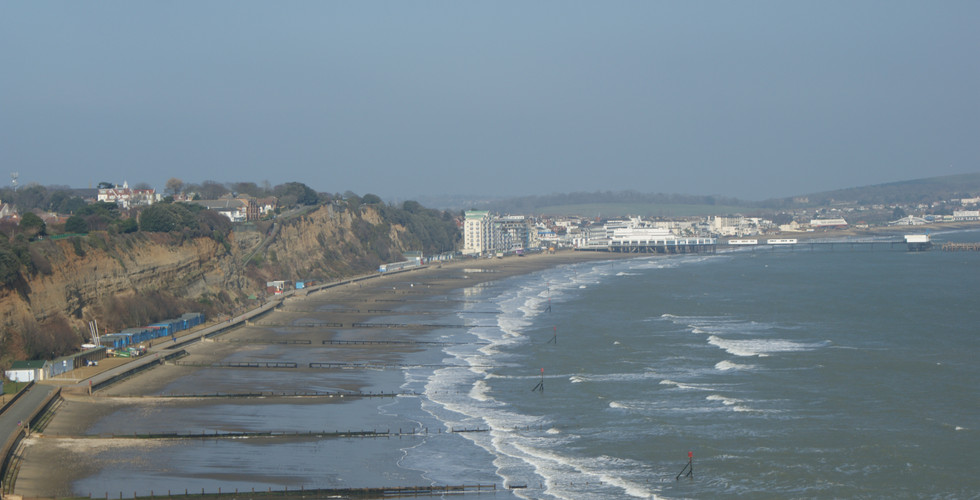
2. Flat coasts
Flat coast is a misleading name, because these beaches often develop dunes. 'Flat' refers to the gentle slope of the terrain when you go from the dune foot to the sea, something cliff coasts do not show.
Flat coasts are made of loose sediment, like gravel, sand or mud. The interaction between erosion and sedimentation plays a much stronger role here than at cliff coasts. Flat coast also refers to bays and inland seas - as long as they do not feature a cliff.
Features:
Sand bars - and possibly rip currents - sand bars are created by breaking waves and are basically just piles of sand. some of them fall dry during low tide. They can be straight, cresentic, closed, open - depending on the shape of the beach, its sand and wave climate. If sand bars are open, you should be careful for rip currents between them. These are strong flows of water that go seaward - and you can't swim against their current!
Low tide channel - a body of water between sand bars or the beach and the nearest bar. Sometimes they dry up during low tide, sometimes they don't.
Dunes - I wrote an entire blog post about these wind-created piles of sand.
Mudflats - areas where silt and clay settles, which fall dry during low tide. There are no large waves here, otherwise silt sedimentation wouldn't happen, but the tide is very dominant. Tidal channels cross this landscape, and the place is rich in food. Mudflats are especially common in temperate climates, since mangroves may develop in warmer areas.
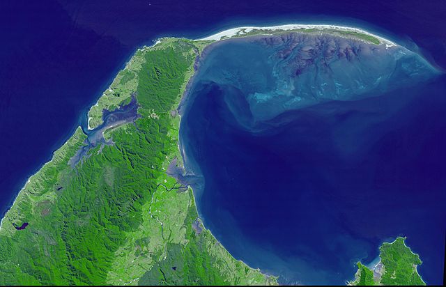
Spits - are long tongues of transported sand at the end of the mainland. They are created by alongshore currents as well and the sediment they carry (aka littoral drift).
Barrier islands and lagoons - barrier islands range from being nearly continuous, but thin (think of the US eastcoast), to only a few kilometers long but relatively wide, having the shape of a drumstick (like the North Sea Waddencoast). Barrier islands are formed when the sea manages to break through a closed coast and keep the gap open. That last one requires a significant tide; the bigger the tide, the stronger the flow velocities in a gap of a certain distance will be. A small tidal range will result in a closed coast, a bigger one in long islands, an even bigger in 'drumsticks', and a huge range will give no islands at all. Ever wondered why the Dutch coast is open in the south, closed in the middle, but open in the north again? it's because of this subtle difference in tidal range. Behind a barrier island lies a lagoon, filled with mudflats and creeks.
Mangroves - Forests that like brackish water in tropical and subtropical regions.
Reefs - to be honest, this one could work with cliff coasts as well, it's a bit of an oddball. The best known reefs are coral reefs, but the word itself reflects to a bar of sand, rock or any other material beneath the water's surface. These things are so complex, they deserve a blog post of their own.


3. Artificial coasts
Considering that most people live close to coasts, it is no surprise humans have done their fair share changing them. This can range from creating more living space by making artificial islands or protecting what we have with dikes and nourishments.
Features:
Dikes - also known as levees, but I prefer the other word. Totally not biased because it has Dutch origins. Anyway, this is probably the most common form of coastal protection. Dikes were made of whatever material was locally available, then covered with something (grass, stones) to keep it there. You often find multiple dikes in one area, of which only the most seaward one has a protective function; the other dikes are remnants, when the sea used to be further inland.
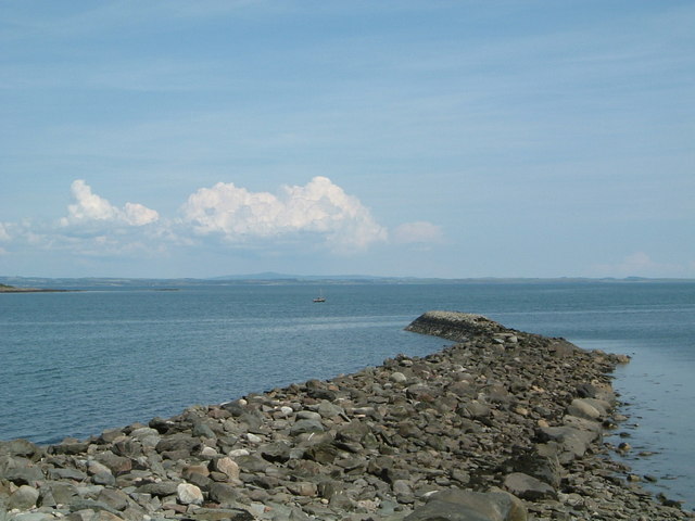
Breakwaters - structures that, like the name implies, break waves to provide safe anchorage.
Groynes - these are dams that run parallel to the coastline into the sea. The main purpose of these features is to break waves before they hit the shore, so that their energy will be used on the groyne and not the coastline the groynes protect, and stimulate sedimentation. That works, but unfortunately, the long structures interrupt sedimentation patterns on large spatial scales, so where they cause sedimentation locally, they will cause erosion further down the coast. It's a system of fluxes, after all; if sand gets deposited earlier than it used to, then that place further down the current will receive less sediment and can erode.
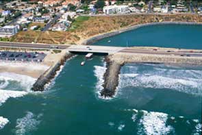
Jetties - structures that protrude into the sea, but they aren't as numerous as groynes usually are and have a different function than breakwaters. Jetties can be used to keep entrances to harbours and rivers fixed, and stop them from silting up.
Islands/land extensions - because why not? Some artificial land makes sense, like harbour extensions when you run out of space, but others... I still don't understand the Palm Islands... Those things have such a bad effect on ecology and currents there.
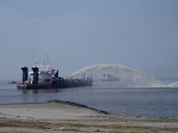
Sand nourishments - the things mentioned above are so-called hard structures, but this is not. Here, sand gets dredged from a place where it can be missed to a coast that suffers from erosion, to prevent further coastline retreat. This sand can be deposited on the beach itself, but it usually gets dumped in sea right in front of the coast so that nature can distribute it from there. In the Netherlands we have this special project called the Sand Engine, which is a super large nourishment that's constantly above sea level. the idea is that this piece of temporary land will erode, so the sand will get transported and settle along the Holland coast (not the entire coast, mind you).


The use of coasts
There is a reason coastlines are so popular to live close to. They provide access to the sea, which is a source of food, but also a quick way of transport if people know how to sail. This gets even better when there is a river nearby, providing access to the hinterland as well. And don't forget tourism!
Since coasts are used by many people, they can be quite under pressure. Think of pollution; that doesn't have to happen locally, since rivers transport everything to the sea. Chemicals get dumped there, ships spill fuel (sometimes they spill cargo, then the beach can be covered with surprises) or oil ends up turning beaches black after a spill from an offshore platform. There are things like overfishing too, a result of humans using the environment more than is sustainable. To be honest, I don't know how much of a problem this was in history, but it certainly is a big thing now. I do know that humans have been meddling with coasts for centuries. There has always been this mentality of 'the sea is our enemy' when it comes to people's land, so mankind has been building dikes and planting marram grass to strengthen dunes for a long time. Coasts are dynamic; humans are not, it seems. They like to keep things like they have always been.
Another thing: living close to the sea means you might get cut off from other things. Large coastal dunes for example aren't very suitable for farming, so what you often see is that there is a town at the seaward site of the dunes focused on fishing (or in a more modern setting: tourism) which has a sister town at the landward side that is focused on farming. Many towns rely on trade, because they usually are so highly specialised in fishing. Many towns specialise in something, but I feel it's more obvious with the coastal ones.
What can you tell in your story?
Coastlines are the result of various things, so what you should do before you start designing your coast, is figuring out what you already know. Start with the geology; what is your coast made of? Then look at the 'wave climate'; is your coast calm, or do waves batter it constantly? To determine this, you need to know how big your sea is, and how strong the wind. If you want to figure this out in detail; there are charts (like this one) where you can calculate wave height based on wind and fetch, if you want to have get an indication of how badass your waves can grow. Just keep in mind that high waves break in shallow water. Anyway, if you have figured all of that out, can you guess if your coast accreting or eroding, or steady as it is? It should give you a good basis. Then you can look at the human aspect; is there something about the coastline that's not in their favour? Many harbours suffer from rough waves or channels that fill up with sediment. Do your people have enough knowledge to handle these problems? And last, but certainly not least; remember that coasts are dynamic. I know cities can last for thousands of years, but when it sits at the edge of the sea, it is more likely to get abandoned or washed away at some point. For example, towns moved seaward when coastlines extended themselves, which often gave rise to a new town that had the exact same name as the old one, but with 'new' added to it. The opposite happened as well: Egmond aan Zee in the Netherlands got halved, losing its church (it got a new one, which stands more landward).

Of course, this is quite severe worldbuilding, don't waste entire chapters on stuff like this. Then again, it's not that hard to shove in some struggles coastal towns have to deal with. Even a character that has a Jon Snow level of knowledge will figure out why half the church has gone missing.
There are plenty of other things your POV character might notice as well. A few things to come to my mind are these (in no particular order):
- Sea birds flying around.
- Fishing is probably a big thing, so show ships, and things related to ships. A harbour is not a must for this: people can bring their ships ashore with the help of beams. These ships had to have flat bottoms and were rather small. Huge ships had to stay in deeper waters.
- A strong, salty smell - stench, even, if you have stagnant saline/brackish water.
- Background noise in the form of breaking waves.
- Lots of wind (depends on the climate though).
- Sea spray, making skin sticky.
- Paint jobs that need to be redone often because sea spray destroys paint. If a nice paint job is important in your story, of course.
- Stuff washing ashore, which can include interesting cargo or wood from ships that sank. Some people have made it their job to search beaches for things they can use.
- People working according to fish migration patterns or tides. If you have a tide of several meters, you want to get into the water at the right time, and only when there is something out there to hunt.
Of course, the more the POV character knows about the area, the more details he will pick up, like knowing the difference between gull species, knowing how to sail, etc., while something like that salty smell and the sound of gulls will be less obvious to him since he is used to it. I hope the things I mentioned above will help you enough to get your inspiration flowing! Like currents. Caused by waves. That erode shores.
Comments